1,691 m²  ·  Br. Cepaka, Kediri, Tabanan  ·  leasehold 28 yrs
WhatsApp
Rice terraces stretching east from the plot boundary in Cepaka, Tabanan
Land for lease 8°35′39.8″S  115°09′05.1″E

Br. Cepaka · Kec. Kediri · Kab. Tabanan · Bali

1,691 m² where the village ends and the sawah begins

A flat, rectangular plot with its own new access road and an eastern boundary open to working rice fields. Zoning information already issued for villa use.

IDR 7,500,000 per are per year  ·  28-year term  ·  IDR 3.55 bn for the full lease

Land area
1,691 m²16.91 are
Tenure
Leasehold28 years, extendable
Zoning
MixedUrban settlement + food crop
Access
Own roadNew 3 m road, west and north edge
Outlook
Rice fieldsEastern boundary, protected (LSD)
Utilities
At the boundaryPower and water on the road

The land

The last plot before the paddies

Most land in this part of Tabanan is either deep in the village or deep in the fields. This plot is the seam between the two.

The eastern boundary is where Cepaka stops. Past it, wet rice terraces run flat to the tree line — land the Ministry of Agrarian Affairs has mapped as protected paddy, which is the reason the view has stayed open.

The western side touches the family compounds of Banjar Cepaka, and immediately beyond them are finished villas with pools. You get the outlook without the isolation: the neighbourhood is established and services already reach the plot line.

The ground is flat and clear, with no terracing to cut and no slope to retain. What is standing on it now is grass and a stand of bananas on the western section.

Access is being rebuilt. A new 3 m road will run along the western and northern boundary and meet the existing lane at the south-west corner, replacing the track that currently cuts through the middle of the plot. It leaves the land in one piece instead of two.

One rule shapes the massing more than any other: within 10 metres of the new road, building is limited to a single storey. Past that band the height allowance opens up — which suits the site, because the far side is the side that looks at the fields.

A fifth of the plot has to stay unbuilt. On most sites that is a nuisance. Here it decides the best part of the design: keep the open ground on the eastern edge and the garden, the pool and the terrace all face the paddies instead of a neighbour's wall. From a first floor set back beyond the ten-metre band, that view runs uninterrupted to the tree line.

Aerial view with the 1,691 m² boundary marked in red, village road along the southern edge, rice fields to the east
Boundary as marked by the owner. The track running north through the plot is the existing lane, which the new road replaces. Rice fields adjoin to the east. North is up.

Zoning & what can be built

Two zones, one parcel

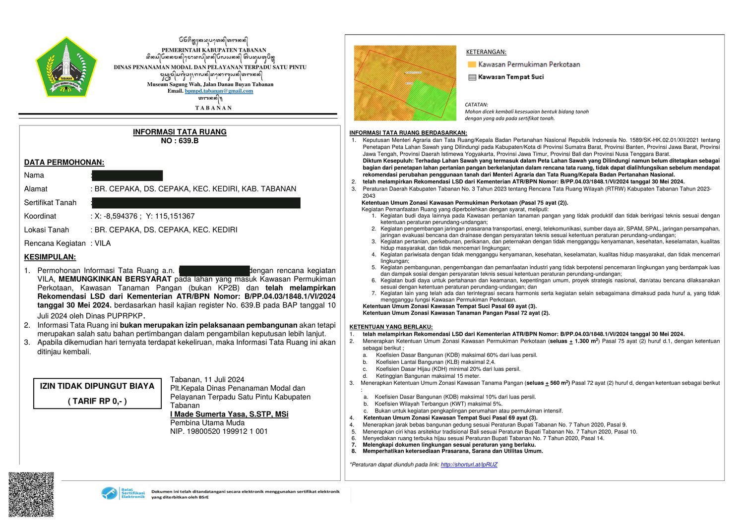
Tabanan's spatial plan splits this land in two. Most of it sits in the urban settlement zone, where the building coefficients are generous. A block in the south-east corner, where the land meets the paddies, stays agricultural and mostly open. Both are covered by the zoning information issued for this parcel in July 2024.

A B 1,691 m² NEW ROAD 3 M EXISTING 2 M LANE TO THE FIELDS PROTECTED RICE FIELD 10 M N

Schematic, not to survey accuracy. The hatched band marks the 10 m strip beside the new road where building is limited to one storey. The road itself sits outside the 1,691 m².

  • A Kawasan Permukiman PerkotaanUrban settlement zone — the buildable part ±1,182 m²
  • B Kawasan Tanaman PanganFood crop zone — kept largely open ±509 m²
Ground coverage (KDB)
60% in zone A, 10% in zone B≈ 760 m² of building footprint in total
Green area (KDH)
At least 20% of the plot stays openEnough ground for a garden, a pool and a terrace on the side that faces the fields
Height limit
15 metres
Storeys near the road
Single storey within 10 m of the new roadBeyond that band, additional storeys are permitted
Access road
New 3 m road, west and north boundaryReplaces the lane that currently cuts through the plot. Already excluded from the 1,691 m².
Intended use assessed
VillaConditionally permitted — memungkinkan bersyarat

The zoning information sets the split at ±1,300 m² and ±560 m² before the 3 m road is taken out. Figures above are the net areas and should be confirmed by survey.

Paperwork

What has already been cleared

Land bordering rice fields in Bali usually comes with a question mark over whether anything can be built on it at all. For this parcel, that question has been answered on paper before it went on the market.

The zoning information can be read here in full. The title deed, the recommendation letter and the signed original are shown at a viewing.

Informasi Tata Ruang No. 639.B issued by DPMPTSP Kabupaten Tabanan Informasi Tata Ruang No. 639.BOwner's name covered Open PDF
Zoning information
ITR No. 639.B, issued 11 July 2024DPMPTSP Kabupaten Tabanan, assessed for villa use
LSD recommendation
B/PP.04.03/1848.1/VI/2024Ministry of Agrarian Affairs / BPN, 30 May 2024 — already attached to the file
Coordinates on file
−8.594376, 115.151367

Conditions that apply

  • Balinese architectural character is required — Perbup Tabanan No. 7/2020, art. 10.
  • Setbacks and green open space per the same regulation, arts. 9 and 14.
  • Sacred area zoning applies to the parcel — Perda Tabanan No. 3/2023, art. 69(3).
  • Environmental documentation must be filed with the building application.
  • Zoning information is not a building permit. A PBG is still required before construction.

The site

Nothing staged, nothing rendered

Location

Twenty minutes from the coast, none of the traffic

Cepaka sits inland in Kediri, Tabanan — north of the Tanah Lot coastline and west of Canggu. Close enough to reach the beach clubs and the surf on a short ride, far enough that the road outside stays quiet.

  • Kediri≈ 6 min
  • Seseh Beach≈ 15 min
  • Nyanyi Beach≈ 15 min
  • Tabanan town≈ 17 min
  • Pererenan≈ 17 min
  • Tanah Lot≈ 20 min
  • Canggu — Batu Bolong≈ 20 min
  • Seminyak≈ 30 min
  • Ngurah Rai Airport≈ 45 min

Approximate driving times outside peak hours.

Price

7,500,000 IDR

per are, per year

Area
16.91 are — 1,691 m²
Term
28 years
Per year
IDR 126,825,000
Full term
IDR 3,551,100,000≈ US$ 200,000 at IDR 17,700 / US$
Extension
Provided for in the agreementTerms to be agreed between the parties at the time
Utilities
Electricity and water run along the boundary road

Contact

Come and stand on it. That is the fastest way to decide.

+62 878 9118 4818

Zoning reference
ITR No. 639.B
11 July 2024
Location
Br. Cepaka, Ds. Cepaka,
Kec. Kediri, Kab. Tabanan, Bali
Coordinates
8°35′39.8″S
115°09′05.1″E
Area / tenure
1,691 m² · leasehold 28 yrs